Golden Circle, black sand and glacier ice
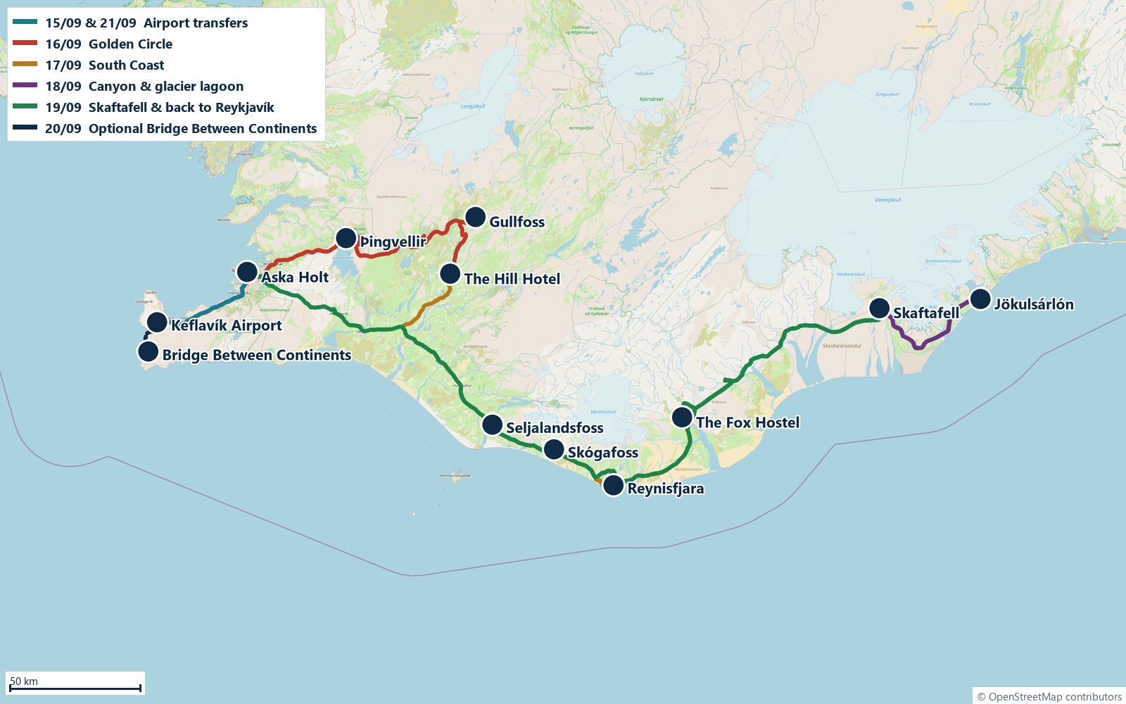
Seven days from Keflavík around the south coast to Jökulsárlón and back. Tap a stop to mark it done; the order is yours, nothing is ticked automatically.
Flights
Where we sleep
Skipholt 29a, 105 ReykjavíkWed 16The Hill Hotel at Flúðir
Vesturbrún 1, 845 FlúðirThu 17 – Fri 18The Fox Hostel
Hrífunesvegur, Hrífunes, 881 KirkjubæjarklausturSat 19 – Sun 20Stay Apartments Einholt
Einholt 2, 105 Reykjavík
Practical essentials
- Headlights on at all times. 90 km/h on rural paved roads, 80 on gravel, 50 in towns. Speed cameras are common and fines are high. Hold the car door firmly when opening in wind.
- Most popular sites charge parking, typically about 1,000 ISK per car, paid at a machine or via the Parka app. Keep a card with PIN for petrol pumps.
- Cards work everywhere; cash is rarely needed. Tap water is excellent. Groceries: Bónus and Krónan are the cheapest supermarkets.
- Nights are dark enough for northern lights; check the aurora forecast on vedur.is when the sky is clear.
- Pack layers, waterproof jacket and trousers, hat and gloves, and sturdy shoes. Weather can change within the hour.
Arrival
Östersund → Stockholm → Keflavík → Reykjavík
Depart Östersund at 06:04 and connect at Stockholm Arlanda. The Arlanda–Keflavík flight leaves 17:10 and lands 18:25 Icelandic time (3 h 15 in the air). Sunset is around 19:50, so you should reach the hotel with the last daylight.
-
Fly OSD 06:04 → ARN → KEF 18:25
Arlanda departure 17:10. Iceland is 2 hours behind Sweden.
-
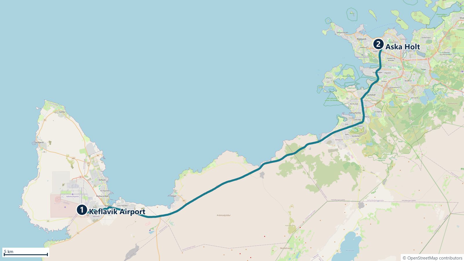
Pick up the rental car at KEF
Rental desks are partly in the terminal and partly off-site with shuttle buses; check the voucher for the pickup point. Photograph the car from all sides and check the gravel/sand-and-ash insurance options.
- 46 km45 minRoute 41 (Reykjanesbraut), dual carriageway most of the way.
-
Check in: Aska Holt, Skipholt 29a
Free street parking; the centre is a 10–15 min walk. Cheap dinner: Bæjarins Beztu hot dogs by the harbour, Icelandic Street Food, or a supermarket run at Krónan.
- Refuel and buy snacks before leaving Keflavík or in Reykjavík. There is an N1 station at the airport exit and several in Hafnarfjörður.
- Reykjavík street parking is free in the evening, but check the zone signs (P1–P4) in the morning.
Overnight: Aska Holt, Reykjavík
Golden Circle
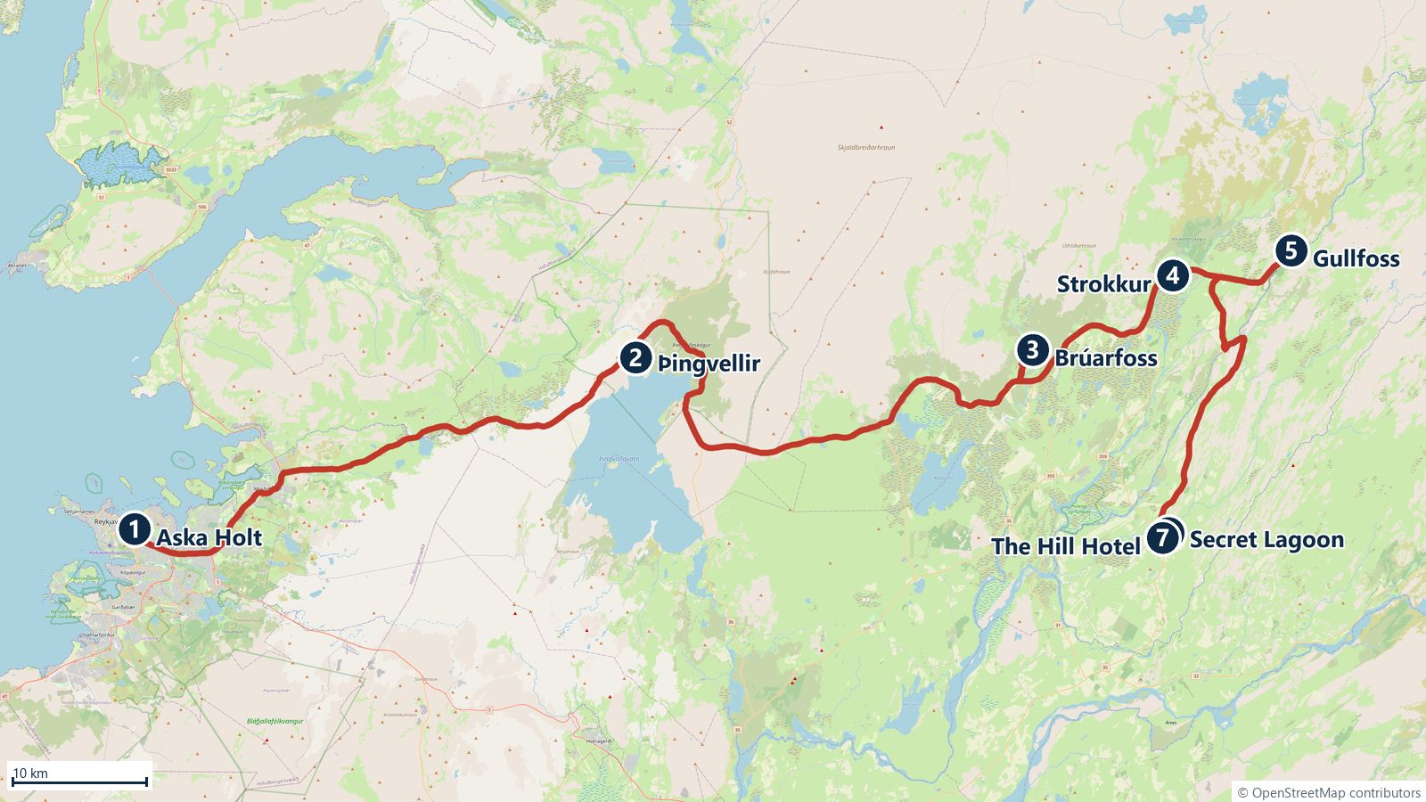
Þingvellir → Brúarfoss → Strokkur → Gullfoss → Secret Lagoon → Flúðir
The classic loop, with two extras: the blue cascades of Brúarfoss and a hot-spring soak at the end of the day.
-
Leave Aska Holt, Reykjavík
Aim for 08:30 so Þingvellir is quiet.
- 45 km45 minRoute 36. Your note: 45 km – 45'.
-
Þingvellir National Park + Öxarárfoss
UNESCO site where the North American and Eurasian plates drift apart, and the site of Iceland's parliament from 930 AD. Park at P1 (visitor centre, Hakið) and walk down the Almannagjá rift to Lögberg, then on to Öxarárfoss, a 20 m waterfall tumbling into the fissure. Round trip about 3 km, 1–1.5 h. Or park at P2 for a shorter (10–15 min) walk to the waterfall. Parking about 1,000 ISK, valid all day across the P lots.
- 48 km50 minVia Laugarvatn (roads 36 → 365 → 37). Your note said 35 km; routing gives 48 km.
-
Brúarfoss
The "bluest waterfall in Iceland": small cascades pouring into a milky-blue glacial river. Since 2023 there is a paid parking lot just off road 37 (Brekkuskógur), then an easy 5–10 min walk to the viewing bridge. Plan 30–45 min.
- 19 km20 minRoad 37. Friðheimar tomato farm (Reykholt) is 10 min off route here: tomato soup buffet, reservations recommended.
-
Strokkur / Geysir
Strokkur erupts every 5–10 minutes to 15–30 m; the original Geysir is mostly dormant. Stand upwind, watch the bubble dome form and keep the camera ready. Free; parking, café, shop and toilets at the Geysir Center across the road. Plan 45 min.
- 10 km11 minRoad 35. Your note: 10 km – 11'.
-
Gullfoss
The "Golden Falls" drop 32 m in two tiers into the Hvítá canyon. Upper viewpoint by the parking/café, lower path right beside the falls (waterproofs). Free; café with the famous lamb soup. Plan 45 min.
- 32 km30 minRoad 35 south, then 30/359. Your note: 32 km – 28'.
-
Secret Lagoon (Gamla Laugin), Flúðir
Iceland's oldest swimming pool (1891), a natural hot-spring pool at 38–40 °C with a small geyser bubbling nearby. Book online; adults roughly 4,000 ISK. Shower without swimsuit before entering. Open in the evening, so it is the perfect end to the day.
- 0.6 km2 minPractically next door.
-
Check in: The Hill Hotel at Flúðir
Vesturbrún 1, 845 Flúðir. Flúðir has a small Samkaup shop and a couple of restaurants; the hotel has a restaurant too.
- If you skip Brúarfoss, Þingvellir → Strokkur direct is 60 km / 55 min.
- Silfra fissure snorkelling in Þingvellir must be booked in advance and takes about 3 h; not planned but worth knowing.
- Kerið crater (road 35, 15 min from Flúðir) is a possible extra if you have energy left; small entry fee.
Overnight: The Hill Hotel, Flúðir
South Coast
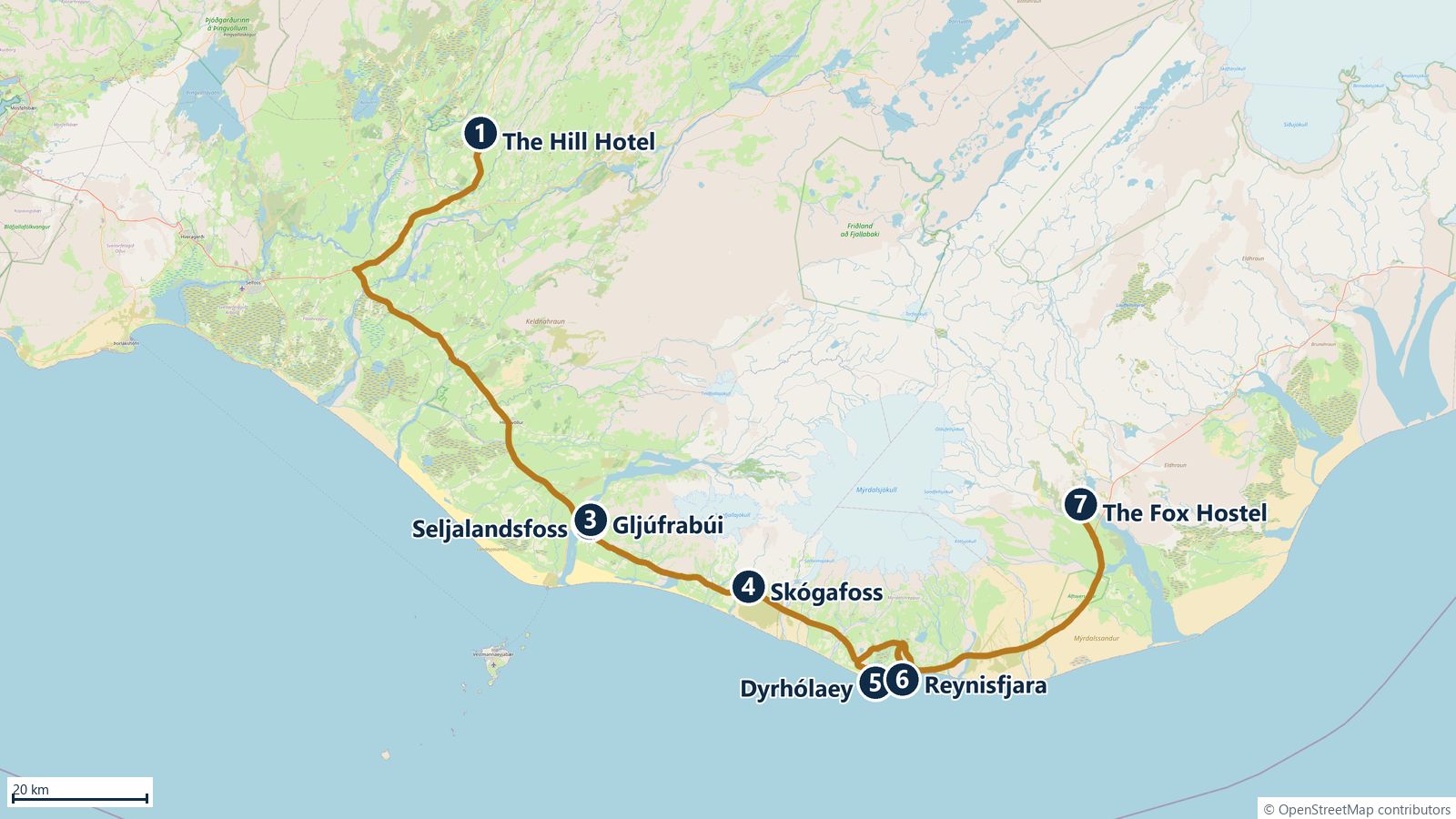
Seljalandsfoss → Gljúfrabúi → Skógafoss → Dyrhólaey → Reynisfjara → Hrífunes
Waterfalls you can walk behind, cliffs, and the black beach. The first leg is the longest, so leave Flúðir early.
-
Leave The Hill Hotel, Flúðir
Fill up in Flúðir or Selfoss.
- 86 km1 h 17Roads 30 → 1. Recomputed; your 34 km was from Hella.
-
Seljalandsfoss
A 60 m waterfall you can walk all the way around: the path leads behind the curtain of water. You will get wet, so wear the waterproofs and protect the camera. Parking about 1,000 ISK (covers Gljúfrabúi too). Plan 45 min.
- 0.9 km2 minOr walk 10 min along the cliff. Your note: 900 m – 2'.
-
Gljúfrabúi
"The one living in the canyon": a hidden 40 m waterfall tucked inside a narrow gorge. You wade a few steps along the stream into the cleft, so waterproof boots are ideal. As your note says: molha! Plan 20–30 min.
- 30 km27 minRoute 1. Your note: 30 km – 27'.
-
Skógafoss
60 m high and 25 m wide, with an almost constant rainbow in sunshine. Walk to the base for the full spray, then climb the 370 steps to the top platform for the coast view (start of the Fimmvörðuháls trail). Parking fee. Plan 1 h.
- 26 km25 minRoute 1, then road 218. Your note: 26 km – 25'.
-
Dyrhólaey
A 120 m promontory with a giant rock arch, views along the black beaches in both directions and the Arnardrangur sea stack. Lower parking (Lágey, by Kirkjufjara) and upper lighthouse (Háey) via a steep gravel road. Kirkjufjara beach itself is closed to walkers since 2017 because of deadly sneaker waves; view it from the cliff paths. Puffins have left by September. Plan 1 h.
- 20 km21 minBack to Route 1, then road 215. Your note: 20 km – 21'.
-
Reynisfjara black sand beach
Basalt column cave (Hálsanefshellir) and the Reynisdrangar sea stacks offshore. Iceland's most dangerous beach: sneaker waves reach far up the sand without warning. Follow the traffic-light warning sign, never turn your back on the sea and stay well above the wet sand. Parking fee. Plan 45 min. Black Beach Restaurant at the parking for lunch or coffee.
- 56 km50 minVia Vík on Route 1, then road 209 (Hrífunesvegur). Recomputed for Hrífunes.
-
Check in: The Fox Hostel, Hrífunes
Hrífunesvegur, 881 Kirkjubæjarklaustur, about 35 min east of Vík. Has a restaurant; check serving hours at check-in. Dark and remote: a great spot for northern lights if the sky is clear.
- Do your grocery shopping in Vík (Krónan) before heading to the hostel. Vík is the last town before Kirkjubæjarklaustur.
- Lava Show in Vík pours real molten lava indoors, 10 min from Reynisfjara. Not in the plan, but it is the only live lava currently viewable in Iceland; book online.
Overnight: The Fox Hostel, Hrífunes
Canyons & glaciers
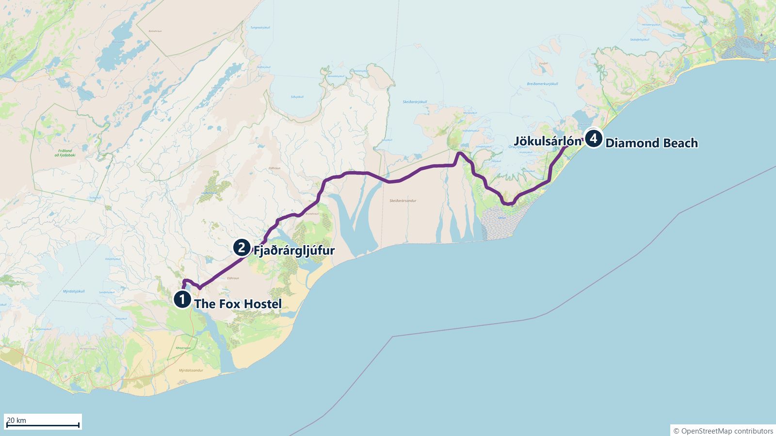
Fjaðrárgljúfur → Jökulsárlón → Diamond Beach → back to Hrífunes
Out and back along Route 1. Leave early: sunset is about 19:40 and you want the lagoon in daylight. You pass Skaftafell (tomorrow's stop) both ways.
-
Leave The Fox Hostel
Fuel up in Kirkjubæjarklaustur before heading east: the next petrol is at Skaftafell/Freysnes.
- 32 km28 minRoute 1 east, then road 206 (short gravel). Recomputed; your 68 km was from Vík.
-
Fjaðrárgljúfur canyon
A 2 km long, up to 100 m deep canyon carved through soft palagonite rock. A well-made path with viewing platforms runs along the eastern rim to the waterfall at the far end; round trip 2–3 km, about 1 h. Stay on the marked path: the moss is fragile and the edges crumble. Parking fee.
- 131 km1 h 52Route 1 across Skeiðarársandur, past Skaftafell. The twisted steel girders by the road are remains of the bridge destroyed by the 1996 glacier flood. Your note: 130 km – 1h45'.
-
Jökulsárlón glacier lagoon
Iceland's deepest lake (about 250 m), filled with icebergs calving from Breiðamerkurjökull, an outlet of Vatnajökull. Seals often swim between the bergs. Boat tours (amphibian about 40 min, zodiac about 1 h) run until early October; book ahead if you want one. Café and toilets on site. Parking fee. Plan 1.5 h.
- 0.35 km2 minAcross the bridge on the ocean side. Your note: 350 m – 2'.
-
Diamond Beach
Where the icebergs wash out to sea and are thrown back onto the black sand, glittering like diamonds. Best light in the afternoon. Walk 5–10 min from the parking on the ocean side of the bridge. The waves are strong here too, so keep a safe distance. Plan 45 min.
- 156 km2 h 13Same road back west. Fjallsárlón, a smaller and quieter glacier lagoon 10 km west of Jökulsárlón, is worth a 30-min stop if time allows.
-
Back at The Fox Hostel
Dinner at the hostel or in Kirkjubæjarklaustur on the way back.
- Bring lunch or eat at the Jökulsárlón café; restaurant options on this stretch are sparse.
Overnight: The Fox Hostel, Hrífunes
Skaftafell & the long road home
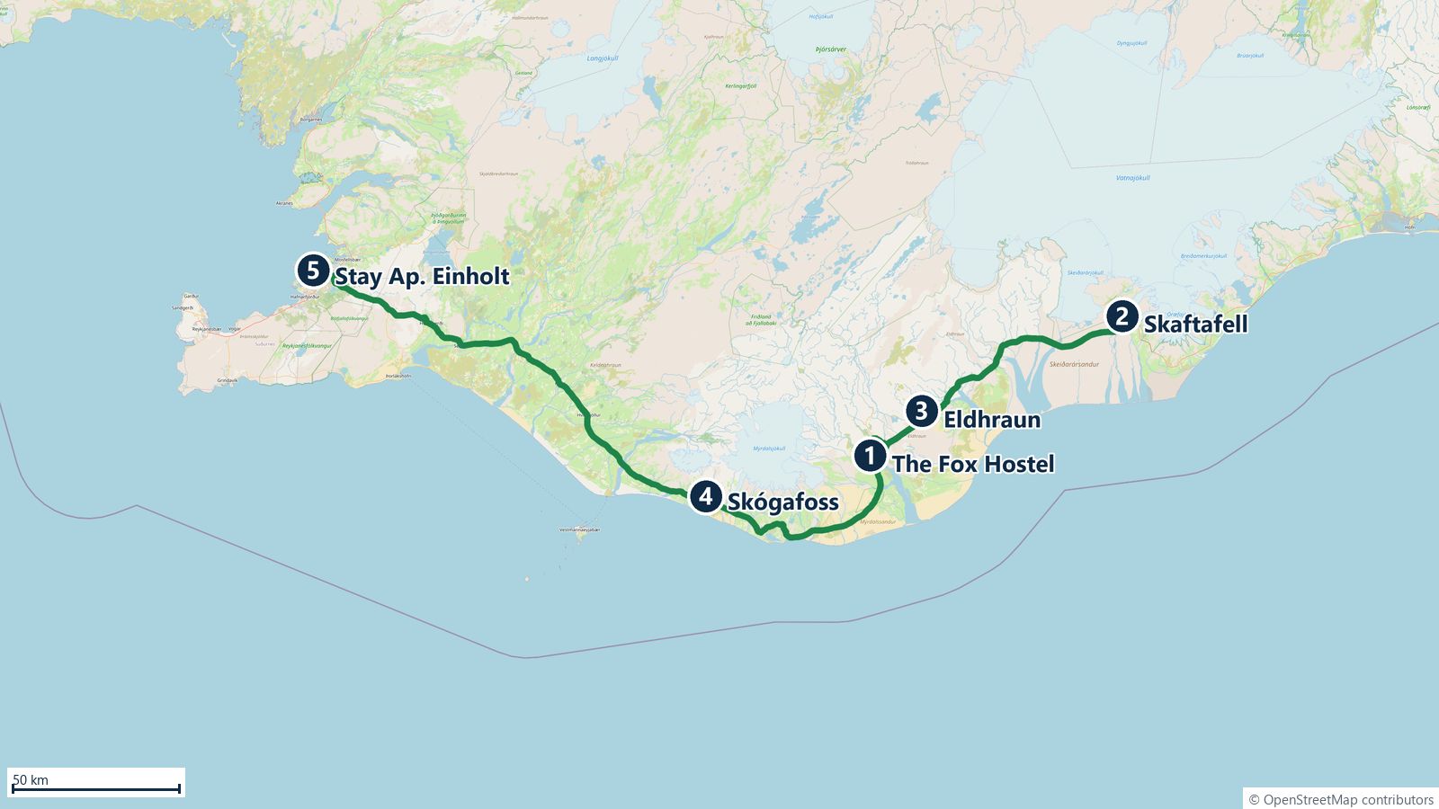
Skaftafell → Eldhraun lava walk → (Skógafoss) → Reykjavík
The longest day: about 430 km either way, roughly 6 h of driving with Skógafoss and 5 h 45 direct. Aim to leave the hostel by 08:00.
-
Leave The Fox Hostel
Check-out, full tank from Kirkjubæjarklaustur if you did not fill up yesterday.
- 103 km1 h 28Route 1 east, past the Fjaðrárgljúfur exit. Recomputed for Hrífunes; your 20 km was from Hof.
-
Skaftafell (Vatnajökull National Park)
Green oasis between glaciers and black sands, with a visitor centre and marked trails. Most popular walk: Svartifoss, the "black waterfall" framed by basalt columns (5.5 km round trip, about 1.5 h, 200 m ascent). Shorter: the flat 2 km path to the Skaftafellsjökull glacier viewpoint (about 45 min). Parking about 1,000 ISK.
-
Glacier walk on Falljökullcaminhar
Walking on a glacier is only allowed with a guide. Tours start at the Skaftafell base (Glacier Guides, Icelandic Mountain Guides, Arctic Adventures): the 3-hour walk has about 1.5 h on the ice and suits beginners. Roughly 14,000–17,000 ISK per person in 2026; 5-hour hikes about 22,000 ISK. Crampons, helmet and ice axe included; boots and waterproofs can be rented. Book online the day before and arrive 20 min early. With the tour you arrive in Reykjavík after 20:00.
- 77 km57 minBack west on Route 1; parking right by the road. Your note: 77 km – 57'.
-
Gönguleið um Eldhraun (lava walk)
Eldhraun is the enormous moss-covered lava field from the 1783–84 Laki eruption, one of the largest lava flows in recorded history (565 km²). A marked parking area on Route 1 between Kirkjubæjarklaustur and Vík leads to a short (about 150 m) rocky path up to a viewpoint over the green lava. Never walk on the moss: it takes decades to recover. Plan 20–30 min.
- 96 km1 h 13Route 1 via Vík. Skip this stop and drive direct: Eldhraun → Reykjavík is 250 km / 3 h 20 (your note).
-
Skógafoss, second visitoptional
If you rushed it on the 17th or the light was bad, the falls are right on the way home. Otherwise drive straight on; the direct route saves only the stop time.
- 154 km2 h 19Route 1 via Hvolsvöllur, Hella, Selfoss. Selfoss is a good place to fuel and eat. Direct from Eldhraun: 250 km / 3 h 20.
-
Check in: Stay Apartments Einholt
Einholt 2, 105 Reykjavík, same neighbourhood as Aska Holt. Often self check-in with a code: read the instructions before you lose signal on the road. Street parking around Einholt/Skipholt is free.
- Petrol is cheapest at unmanned Orkan/ÓB/Atlantsolía stations.
- Sky Lagoon (Kópavogur, 15 min from the centre) is an option for a relaxed evening after the long drive; book online.
Overnight: Stay Apartments Einholt, Reykjavík
Reykjavík
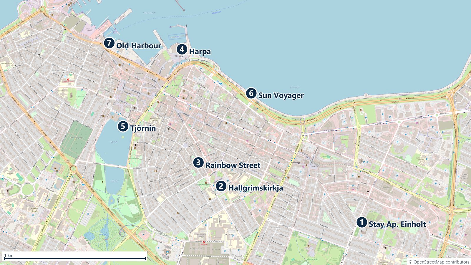
Hallgrímskirkja → Rainbow Street → Harpa → Tjörnin, Sun Voyager, Old Harbour
A day on foot: all city stops are within 2 km of each other, so leave the car parked. The walking loop is about 6 km.
-
Hallgrímskirkja
Reykjavík's landmark church (74.5 m), its concrete columns inspired by basalt formations like those at Svartifoss and Reynisfjara. Take the lift up the tower for the view over the colourful rooftops, the bay and Mount Esja (adults about 1,400 ISK, open roughly 09:00–19:30 in September). The statue in front is Leif Eriksson, a gift from the USA in 1930.
-
Rainbow Street (Skólavörðustígur)
The rainbow-painted street leading straight down from the church, lined with design shops, galleries, wool sweaters (lopapeysa) and cafés. Coffee: Reykjavík Roasters (Kárastígur) and Brauð & Co for cinnamon buns.
-
Harpa Concert Hall
The glass honeycomb by the harbour, designed with artist Ólafur Elíasson. Free to walk in and explore the foyers and the play of light in the facade; guided tours and a café/shop inside. Best photographed at dusk when the LED facade lights up.
-
Tjörnin, Sun Voyager & Old Harbour
Tjörnin is the city pond by the town hall, full of ducks, swans and geese. From Harpa walk east along the waterfront to the Sun Voyager (Sólfar), the steel boat sculpture facing the bay, then back west to the Old Harbour with its whale-watching boats, fish restaurants and the Grandi district (Marshall House, Ómnom chocolate, Grandi Mathöll food hall).
- 59 km55 min each wayRoute 41 towards Keflavík, then road 425 past Hafnir. Evening drive, about 1 h 50 round trip.
-
Brú milli heimsálfa: Bridge Between Continents7*
A small footbridge spanning a sand-filled fissure on the Reykjanes peninsula, symbolically linking the North American and Eurasian plates. Free, 15-minute stop; stark lava desert, dramatic in evening light. Close to KEF, so it also works on the morning of the 21st if you leave early. Check safetravel.is first: the peninsula has had repeated eruptions since 2023 and roads near Grindavík are sometimes closed.
- Reykjavík street parking is charged in the central P1–P3 zones also at weekends; the meter or the Parka app shows the exact hours. Free in the evening.
- Perlan (the glass dome on Öskjuhlíð hill) has an ice cave exhibition and a great viewing platform if the weather turns bad.
- Icelandic hot dog with everything ("eina með öllu") at Bæjarins Beztu near the harbour is the classic cheap lunch.
- Pack the evening before: check-in at KEF for the 10:30 flight opens early.
Overnight: Stay Apartments Einholt, Reykjavík
Departure
Return the car at KEF. Pryscilla 10:30 to Montréal, Stefan 11:00 to Stockholm
Both at the terminal by 07:30, three hours before the first flight. KEF security lines can be long on Monday mornings.
-
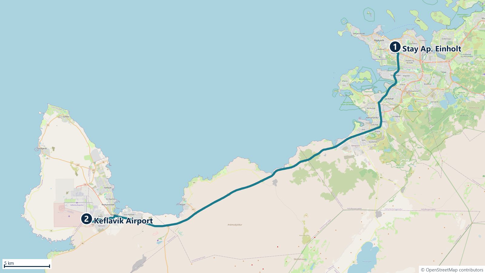
06:15 · Leave Reykjavík
Refuel on the way (N1/Orkan on Reykjanesbraut) so the tank is full at return.
- 46 km45 minRoute 41. Allow extra for refuelling and the rental shuttle.
-
07:00 · Return the car
Shuttle or walk to the terminal. Keep the return receipt and the final fuel receipt.
-
07:30 · Check-in and security
Tax-free refund counter is in the departure hall (before security) for purchases over 6,000 ISK in one shop. Flights to Canada have their own passport control and often a separate security check before the gate.
-
10:30 · Pryscilla departs KEF → Montréal (YUL)
Arrives 11:55 local time. Returns via KEF on 30/09: 07:35 → ARN 12:45.
-
11:00 · Stefan departs KEF → Stockholm Arlanda
Góða ferð!
- Duty free at KEF is cheap for Icelandic chocolate, salt and liquorice, but Brennivín and wool sweaters are cheaper in town.
Overnight: —